 |
| View from halfway up Old Spiral Highway |
Woke up early early early. I asked that we try to get ready and out of there in 30 min. Jay thought 60 was more reasonable. He was right. We rolled out of camp at 6:30 (I think? Or was it 7?) and peddled to Hazel's Good Eats, a restaurant in Clarkston that was highly recommended for a fueling breakfast.
When we entered, I was overwhelmed by the decor, with each booth having it's own assortment of decorations. Ours was a jungle, with stuffed animals peeking out everywhere, and fake vines and leaves hanging down.
 |
| Our booth had the big cats. |
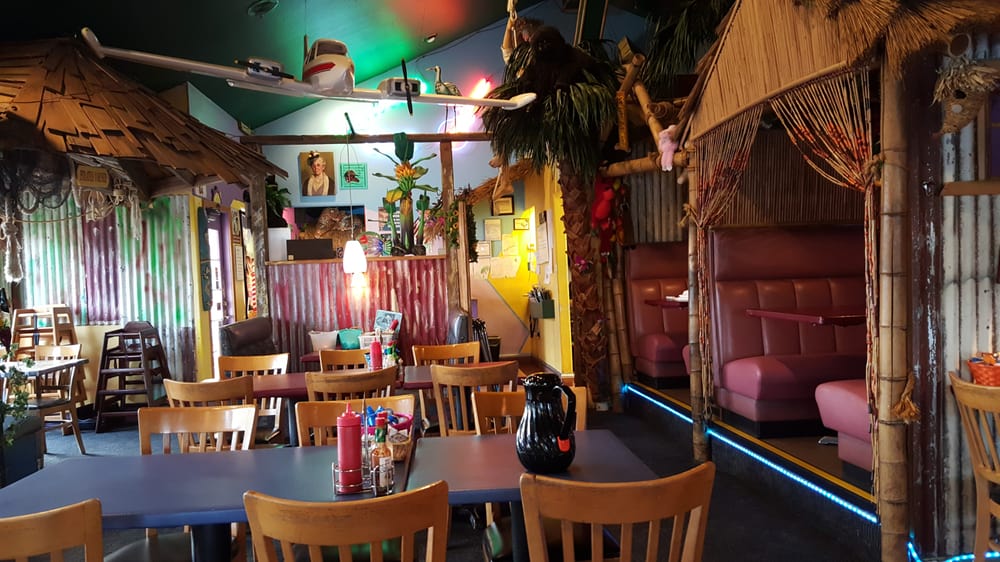 |
| Inside of restaurant |
The recommendation was well deserved. We each had a hearty breakfast, had some decent coffee, and the server asked if we would like our water bottles filled with ice and water. Awesome!!!! (The server is worthy of a story all her own. She was a classic small-town character, 8 months pregnant with her second child and still working full time.) My two bottles, Jay's two bottles, and his nalgeen bottle were wonderfully full and chilled as we loaded up and headed for the bridge where our Clarkston visit began yesterday. Thankfully going this direction, there was a separate bike/pedestrian section which was not nearly as debris laden, so we passed without getting flats.
 |
| Red Wolf Crossing bridge. Right side is RV park we rested at. Left side is Wawawai Rd coming in. And straight ahead is the Old Spiral Highway area.... |
The section of highway from the bridge to the base of Old Spiral Highway road had a narrow shoulder and fast traffic. Though Jay had recommended a slow, steady pace for the 4 miles before we started climbing, we had no choice but to go as quickly and efficiently as possible.
 |
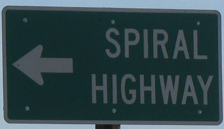
| Sign on hwy. |
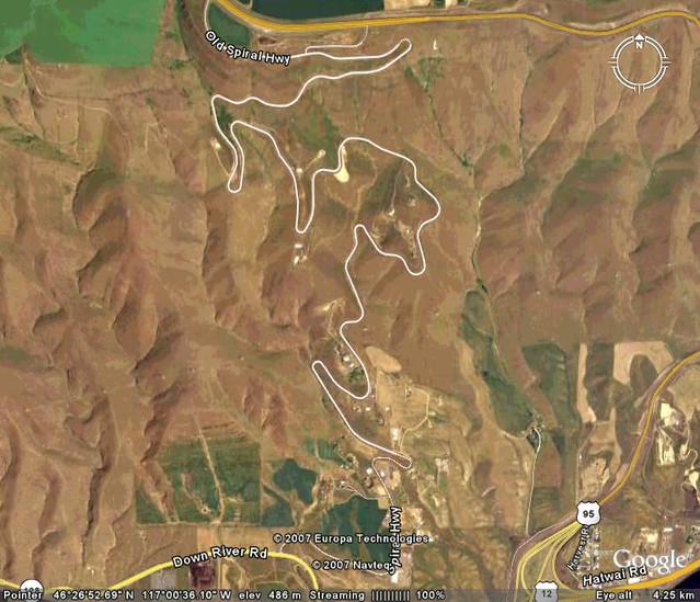 |
| Aerial View of Old Spiral Highway. Seven and a half miles, climbing 1,781 feet. |
And then the climb. Things can become larger than life when everyone you talk to asks if you are going "up the Spiral Highway." And then they shake their heads with a hint of pity when you say yes. Yikes! I thought of the old roads in Humboldt County that were so steep my un-laden Trek struggled. But I calmed myself, reminded myself that we got through Hells Canyon yesterday, so we could do this.
 |
| View, looking toward Clarkston. |
As soon as we started, I breathed a huge sigh of relief. This was going to be fine. Yes, we were settled down into our easiest 3 gears, and it was going to be a long hour to get to the top, but it wasn't overfacing or overwhelming. My bike and my legs and lungs could do this. It was also blessedly overcast (Jay had mentioned earlier that a thunderstorm had been predicted, then cancelled. More on that later.....hint hint).
 |
| View, looking towards the Snake River and where we camped at the state park. |
The road reminded me of the Tour of the Unknown Coast, especially the Panther Gap section going up the mountain before dropping into Mattole Valley. All the switchbacks. Except these switchbacks were very well banked, unlike the Mattole road. Some of the switchbacks on Old Spiral were so deeply banked that the road-to-wheel angle was close to 45 degrees, with us at the "top" side of the bank!
 |
| A stock photo of the switchbacks. |
The views as we climbed were spectacular. Arriving at the top felt like a significant accomplishment. We took the obligatory photos with the elevation sign, and then pushed on to Hwy 95. (Jay has the pictures, so check out his post...)
 |
| At pullout a few switchbacks below the top. |
 |
| Jay rocking his cool shirt. Literally and figuratively cool. |
The section we entered was being re-surfaced, so it had gravel that was being packed into oil. There were two lanes going each direction, but the road work had cut it to one lane each way, and the "shoulder" was a bath of gravel in various depths and firmness. How Wonderful! Jay got a head start, and with the noise of our wheels on the gravel and the cars whizzing past, we couldn't communicate. In my mirror, I watched as an rv, drunk on speed, came up on me, careened past me and made a bee-line for Jay, who was going around a ridge of gravel in what should have been the bike lane. I yelled, "Jay, Move Over!!!" I don't think he heard me. I cringed as I watched the RV close in on him, (This is my lane, and I have the right of way, and I need to drive at top speed, even though the road is covered with gravel and there is a bike up ahead!) and just as it drew up to his bike, it veered sharply to the left in between two cones, and then veered sharply back. Luckily, Jay had reached the end of the gravel ridge, and had moved over just in time, too. Never occurred to the driver to slow down, I guess.
 |
| A stock photo of work being done on this stretch of road..... |
Soon after, the road opened up to two lanes again, and we had some relief for the remaining mile before we turned off onto HWY 195, which led us back into the Palouse hills on the way to Pullman. Before we reached the turn off, I was thinking back longingly to the scored loneliness of Wawawa rd along the snake River. Kind of.
 |
| Hwy 195 (we were going north) and the nice wide shoulder. |
HWY 195 wasn't a low-traffic road, and the traffic included a lot of RVs and Semis. But we had good shoulder and good visibility. About those Palouse hills. These perfectly rounded hills were all cultivated with wheat and the occasional cover crop of mustard in full bloom or another nitrogen fixing plant. The hills were perfectly plowed, planted, and harvested in narrow, evenly spaced rows that followed the contours of the land, like magic. The machines go one way on one pass, and then the opposite way on the next pass, so the texture of the land or plants looks like velvet that has been stroked in different directions so the pile lays differently. Jay nailed it when he said the hills looked like they were covered in corduroy. Below are different stock photos of the Palouse in different shades.


Some hills looked like green or brown or tan-palette-ed Jupiters with mono-chromatic bands of color. It was a perfect study for a Van-Gogh-style painter or a pastoral landscape artist. It was simultaneously very fake, the mono-culture, and very beautiful, the way the crops are sown all over the hills. Land has to be a very steep slope for it to not be planted. And the furrow lines follow the curve of the land perfectly.
We imagined farm kids, learning to drive tractors, pushing the envelope and trying to go on slopes that were a smidgen too steep, and tipping the tractor.... and losing their tractor privileges for a few years, never to live it down....

At last, we arrived at Uniontown. Now there was a lot of pressure on this town, from the write-up in the tour book we used as a guide. This was a "Must Stop." Well. We stopped. We expected to eat here, and water up, and rest a while. We wheeled down a pretty deserted main street, with NO open stores. Most were permanently closed, and the one that was still open--Sage Baking Co--has the most interesting hours. Closed Monday which was today. Okay, next stop, Holzer Park next to main street.
 |
| The community center, where Jay got water. |
 |
| Add caption |
Jay checked the water faucet. Dry. We watched someone stop their car to use the public restroom. Locked. Well, this was not what we expected. We've got another 20 miles to go to Pullman. Jay took the water bottles to an office that was open (we saw several people go in and out) to fill up, and I got things organized at the picnic table we picked. When he got back, we made hot cereal using his completely amazing little stove. The magic simplicity of it awes me.
 |
| Tired Jay drinking well-earned water after eating, but before we moved to Memorial park |
 |
| This is what a tired and happy cyclist looks like. |
While Jay finished cooking, I explored the Uniontown web page to look for other parks. There was one a few blocks east, Memorial Park. I took a trip to see what it was like, and discovered it had working bathrooms, working potable water faucets, and covered picnic areas. I returned, triumphant, and after we ate we loaded up and moved our mid-day camp.
 |
| Stock photo of Memorial Park. We rested in the shelter to the left of the young girl. |
It was now the height of the heat of day, and we were fairly worn out from our morning climb (slow going, but boy we burned some calories!). So we took a nap in Memorial Park. When we awoke, the barometer has shifted. Now there was a cool wind blowing everything about, and the skies had that tone of darkness to them that signaled impending storm. Jay checked the satellite map, and saw that the on again/off again prediction of a storm was back on. So we hustled. Below are some stock photos of the Palouse area, in storms. The darkness of the sky, against the green of the hills was striking, like in these pictures.


Didn't take long for the storm to arrive with ominous darkness to the south-west, and then the lightening and thunder began to explore the skies. We considered the dangers of riding metal bikes on relatively flat land with lightening around. I picked up my pace without realizing it, and Jay commented, "It is no use trying to out-run the storm, if you are trying...." About 7 miles out from Uniontown, we pulled into a parking area in front of a farm house to check the weather map and fuel up. We decided to keep going.
 |
| Stock photo of storm on the Palouse. |
A quarter mile down the road, Jay stopped and recommended we turn around. He shouted this, because now the wind was so strong it snatched our voices away. The wind was behind us, and he realized it was pushing us up the hill because we were going far faster than we had any reason to be, with our heavy bikes. We turned around and attempted to quickly return to that farm house. Phew! Loaded bikes offer up much more surface area to wind! (more stock photos below. Jay got the good pictures)


In the shelter of the porch, we watched the wind dance through the wheat, watched the rain torrent down, and shuddered at the lightening coursing through the skies. At one point, the empty flag pole bracket near my head sizzled and cracked with a jolt. Yes, there was electricity in the air. Jay watched the satellite image, and saw the storm was passing, but another storm cell seemed to be coming behind it. Should we head out and try to beat it?
It looked like things were starting to mellow out. Then the home owner arrived, and invited us in. She went in through the garage, and on her way to the door, she picked up her husband, who was not nearly as welcoming. His words were, I believe, "It looks like it's easing off, you can head out now." So we did. The wind had subsided and the rain was just spitting now. The 12 miles to Pullman were drenching, only because the passing cars and semis kept putting water into the air.
One car, being so polite, moved over, but their wheel hit a hole in the road, and sent a rocket of water my direction, soaking my face! We channeled our inner Dory again.... Just keep spinning, just keep spinning. At last, Pullman arrived. We entered from the south end of town, and decided to stop at the first promising looking restaurant. Suddenly, there appeared a Thai restaurant!.
 |
| Phikuns Thai Cuisine, Pullman WA |
Ah, sweet! Jay ordered chicken noodle soup to keep healing the cough he was still struggling with. I ordered golden tofu with wide noodles, vegetable, and peanut sauce (continuing my quest to find a peanut sauce out there as good as mine. Still looking). The portions were so large, Jay took home half of his soup in his Nalagene bottle for breakfast.
 |
| Check out the size of that bowl of soup! |
 |
| Hot Tea is good. |
After filling our bellies, we made our way back to the van and bedded down for the night. How wonderful to crawl into the van and get warm and cozy after the cold of the afternoon rain. Tomorrow's ride out to Troy is an easy one, with no need for early rise. We agreed to just sleep.
Oh, and our panniers ARE water proof.


What an awesome adventure!
ReplyDeleteStill more to tell! Every day had it's amazements. We're getting ready to head out for our next trip, to the coast. :) Thanks for stopping by!
DeleteThis comment has been removed by the author.
ReplyDelete